Monday, 31 October 2022

Redcar to South Gare

With our fine weather, weekend visits to Lakeland dying a death this year, my wife and I decided to resume our North-East coastal adventures with a trip down to Teesside on Sunday. We'd been to Redcar and its sandy expanses before, but not for a good few years; so we thought we'd renew acquaintances.

To tell the truth, we didn't really call in at Redcar proper, but rather parked up at the fancily-named Majuba Car Park on the front (essentially at Coatham, I suppose) with the intention of setting off along the beach westwards towards South Gare and the mouth of the Tees. First of all, however, we had a hot chocolate at the local Recreation Centre, and Angie insisted on a visit to a local ice cream parlour a couple of hundred yards in the opposite direction for her customary 'Lemon Top'. Well, Redcar is supposed to be the home of the tasty creation.

Meanwhile, I busied myself with a look at the Redcar Beacon:

The Beacon, we are told, is Redcar's 'vertical pier', "offering visitors the chance to enjoy a 360 degree view of the seafront". The viewing platform was, however, closed due to 'antisocial behaviour', or some such reason.

Never mind, off we set to the west along a four mile stretch of really quite beautiful beach that links the town to the mouth of the Tees at South Gare - an expanse of natural beauty known, I think, as Coatham Sands. Here I regaled my wife with the well-known story of how the Dunkirk scenes from the film Atonement were set here in 2006. Suitably bored with my historical banter, she sucked noisily on her gelato concoction whilst I largely talked to myself.

The walk was a long, if pleasant, one; the natural beauty of our surroundings punctuated rudely by the whirling offshore wind turbines and, of course, the looming gaze of the half-demolished Redcar Steel Works.


As the pier at South Gare approached we looked for a way to get as close to the end of the structure as possible. The warning signs put us off, though, and we satisfied our curiosity with a little dead-end expedition along the western fence of the pier and a snoop around the nearby gun emplacements known as the Coastal Battery.

View along the pier from atop the battery

Coastal Battery, with Steel Works in distance

View across the Tees from South Gare

On our way inland along the South Gare access road, we stumbled upon a couple of other famous landmarks, thus:

Fishermans' Huts, South Gare

Paddy's Hole, South Gare

We continued southwards along the access road, inland, before turning eastwards towards the skeleton of the Steel Works. Along this narrow, dead-end road we noticed more than a dozen parked-up camper vans, many, many cars, with an almost constant stream of fresh incomers. We wondered quite what was going on in this remote corner of Teesside at such a late hour (there was only a limited amount of daylight left) and joked that it might be something of a sordid nature. Subsequent research has revealed that we weren't wrong.*

One of the final vehicles that sped past us before we veered off across the sand dunes was a police car. Mmm. Anyway, off we strode, back to the beach, and thence eastwards back to the car. And at the car park I found a fading information board, a part of which I shall reproduce below for your convenience:

(click to enlarge)

We just avoided a torrential downpour which swept across behind us (which may or may not have hampered proceedings back at South Gare), and drove back north as night began to fall. Another little stretch of North-East coast completed - and we'll be back to the seaside for more as the winter progresses.

Very interesting.

* use your imagination. And Google, perhaps. 


Friday, 21 October 2022

Favourite Newcastle Books No.2: 'Victorian Panorama'


Victorian Panorama: A Visit to Newcastle upon Tyne in the Reign of Queen Victoria is one of the many works on the subject of the city's history by Alan Morgan; and is, in my opinion, one of the very best of the past couple of decades. Essentially, it takes one of the classic artistic views of the town (dating to 1862) and forensically examines the fine detail of the same, section by section. A simple idea, brilliantly and thoroughly executed.

The painting itself was by John Storey, and, intriguingly, includes structures that were not built until several years after the 1862 date (we think, therefore, that he must have access to future plans, etc.). The book opens with an outline of the artist's life, and provides a factual summary of the town of the 1860s. There follows ten chapters on various areas of the town centre and its closest suburbs, as well as three on Gateshead, then a few pages on 'The Coaly Tyne'.

Each chapter is heavily illustrated, including maps aplenty, the highlights being the exploded sections of the painting itself which have been shaded and labelled to make examination and exploration foolproof - which I hope you can at least partly tell from the image below.

(click to expand)

Helpfully, the text is colour-coded, thus: "Entries within each chapter are headed in red if the street or structure has been demolished, or in blue if they can still be seen." This makes it even easier to negotiate one's way around the cityscape - quite literally if you wish - which really does bring the Newcastle of 160 years ago to life. An absolute pleasure to cast your eyes over.


A little tricky to get these days, it being quite expensive on Amazon/eBay - but do get hold of a copy if you can. Close examination of the above image reveals that I was lucky enough to secure mine from Oxfam for £1.99!

Victorian Panorama: A Visit to Newcastle upon Tyne in the Reign of Queen Victoriaby Alan Morgan, published by Tyne Bridge Publishing, 2007 (paperback, 108 pages). 

Wednesday, 12 October 2022

The Romans at Denton

Those of you who endured my ramblings about my relationship with the Roman ruins near my childhood home in volume 1 of The Great North-East may be interested in a little further detail. And those of you who didn't ... well, you may want to at least look at the pictures.

So blasé was, and indeed still is, my attitude to the multiple stretches of Roman Wall in Denton, that I didn't even have any personal photographs of them. So the other day I thought I'd put that right and go have a proper look at the ancient specimens in question. We'll have a look at them east-to-west.

OK, then. Remember that the Roman (or Hadrian's) Wall ran roughly along the course, westwards, out of Newcastle, all the way along the West Road and way beyond. If you begin at the junction where Denton Road / Silver Lonnen meet the West Road, then you will see a petrol station - pretty much on the roundabout. It's a busy little corner of the western suburbs; but have a look on the forecourt and you will see our first little taste of the old frontier, thus:


Yes, that's it. But a few yards further on, on the other side of the neighbouring restaurant, can be found:


Yes, and that does say 'Wonderwall' in the background (deary me). Remember, we're celebrating the 1,900th anniversary of the Wall this year.

Moving on through Denton's shops and beyond the footbridge, you will find an especially interesting section of stonework, known as Denton Hall Turret:


As you can see, this is an especially tempting piece of 'climbing frame' material for kids, and I played my part regularly on this old turret half a century ago (OK, I'm not proud).

Finally, a short walk westward (beyond the big roundabout where the West Road crosses the Western By-Pass) brings you to another long stretch of masonry:


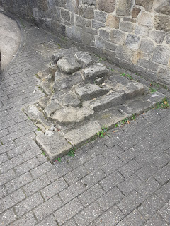
After this point the busy A69 sweeps over the course of the Wall; the foundations of the road no doubt containing several ton of scattered Roman rock. That's it, I think, until you get to an especially impressive section at Heddon-on-the-Wall.

And, yes, I'm afraid I did briefly tread on the Wall at Denton Hall Turret ... just for old times' sake.

Thursday, 6 October 2022

Ghosts of Heavenfield

Those of you who know a bit about the history of the North-East of England will be aware of the importance of the battle of Heavenfield. To briefly re-cap, this took place in 633 (or 634) AD at a spot just off the present-day Military Road (B6318) about a mile east of Chollerford, and represented the kingdom of Northumbria's greatest Dark Age moment: the military victory that signalled the start of our 'Golden Age'. Basically, Northumbria, in disarray following King Edwin's death, was rescued from falling into the hands of the pesky pagans to the south by Oswald and his army sweeping down from exile in the north. 

He is supposed to have secured the backing of his Christian god before the encounter, raising a cross around which to rally his troops before the clash. Anyway, we won, and the spot has kind of remained sacred to us ever since. I have previously written about the battle here.

Earlier this year my wife and I drove past the spot in question. On a whim, I asked to her to apply the brakes, and off I scurried across the fields to have a closer look at the church in the distance. Naturally, it's called St.Oswald's.

The view from the roadside, complete with replica cross. Church in distance...

... And close up.

Happily, it was open. So in I crept and had a nose around. It was a sober interior, as you can see:

Nothing fancy.

Now you just never know when you're going to trip over a new piece of historical info. This time I was especially taken by the 'hatchment' hanging upon the wall; and, handily placed nearby was a helpful information sheet which suitably enlightened me as to not only this particular example, but to hatchments in general. Anyway, for no other reason than I found it interesting, I reproduce below two images of the hatchment of St.Oswald's Church and the info sheet provided.

Robert Clarke's hatchment, suitably restored.


(click on image to enlarge)

Then, as I was on my way back to the wife/car I came across one of those mounting blocks, situated just inside the graveyard. Don't you just love 'em?


Anyway, that's all I had time for. The wife was probably getting impatient by now...